According to data from Fortune Business Insights, The global geofencing market is estimated at $3.23 billion in 2025 and is projected to reach $11.85 billion by 2034. This growth is driven by a number of factors, such as the increasing demand for location-based services and real-time analytics. This powerful GPS function It can bring huge benefits to your fleet operations, and today we will show you why your fleet business needs it.
In this article, you will:
- A geofence is a virtual boundary that sends an alert when a vehicle or device enters or leaves a designated area.
- It uses GPS, motion data, Wi-Fi, RFID, and Bluetooth to accurately track movement.
- Geofencing helps businesses protect assets, better manage their fleets, and improve driver accountability.
- Simply choose the right software, define clear zones, configure alarms, and train employees to get started easily.
What is a geofencing?
A geofencing technique creates virtual geographical boundaries that trigger specific actions, such as sending notifications, when connected devices enter or leave the designated area. Various technologies are integrated into the software to enable this application. These technologies include Global Positioning System (GPS), mobile data, Radio Frequency Identification (RFID), or Wi-Fi.
Geofencing technology is widely used in the marketing, advertising, and fleet management industries. For example, in the retail industry, geofencing is used to send personalized alerts to the mobile phones of customers located near stores.
In fleet management, Geofencing is used to monitor the movement of vehicles, drivers, and assets. It also allows businesses to see when drivers deviate from suggested routes. Furthermore, geofencing helps logistics companies track when packages leave their warehouses. In this way, geofencing technology allows recipients to receive notifications of order movements.
How do geofencing work?
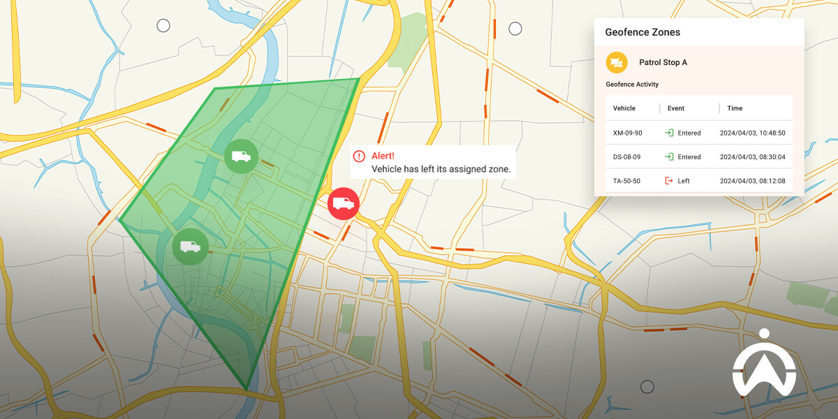
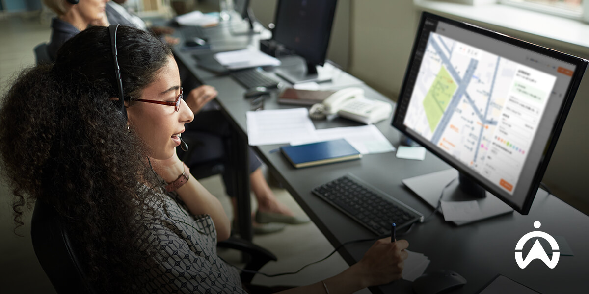
Geofencing via The cloud-based fleet management software platform is in operation. It is established by drawing boundaries on a map. The drawn shape can be any shape, and the boundary can represent places such as warehouses, restricted areas, high-risk areas, or unloading points.
Within a geofence, GPS is the primary tool for accurately locating the real-time position of devices or vehicles. RFID (Radio Frequency Identification) uses tags and readers for short-range location detection over a relatively small area. Wi-Fi helps devices connect to specific networks inside buildings or in urban areas.
Motion data uses nearby cell towers to help estimate device location, while Bluetooth technology is used as a beacon to enable precise tracking in enclosed spaces such as warehouses.
Types of geofencing:
| Geofencing types | Shape/Design | Best use case | Use Case Examples |
| round | A circle centered at a single point. | Quick setup, simple boundaries, general position tracking. | A 2-kilometer radius was set around the warehouse to monitor vehicle arrivals and departures. |
| polygon | A custom shape boundary for a polygon composed of multiple points. | More accurately covers irregular areas. | Precisely define the boundaries of construction sites or mining areas. |
| route | A boundary established along a specific path. | Monitor movement along roads, highways, or delivery routes. | Ensure that the trucks follow the designated delivery routes without deviating. |
Why You Need to Invest in Geofencing Technology
As a fleet manager, it is crucial to know the location of vehicles and assets at all times. Geofencing empowers you... The ability to create virtual fences in specific areas simplifies this process. These can be locations relevant to your daily business operations. It helps you protect your fleet, reduce risk, and improve how your fleet operates.
The specific method is as follows:
Enhance security, theft prevention, and asset protection
Preventing theft is one of the top priorities for every business. Geofencing helps protect your vehicles and assets by monitoring entry and exit points. You'll be notified immediately whenever a vehicle crosses your defined boundary. For example, if a truck leaves the parking lot after work, you'll receive an instant alert and can take swift action. You can also set up geofencing around known high-risk areas to further reduce the risk of vehicle theft.
Better fleet and asset management
Geofencing helps you monitor movement along delivery routes or within specific work sites. This way, you'll be able to spot when drivers... Deviating from the route Taking unplanned trips or idling for too long can cause problems. You can address these issues and educate your drivers about the impact of such behaviors on fuel costs and vehicle maintenance.
Enhance employee and driver accountability
Your drivers play a crucial role in fleet operational efficiency. Geofencing helps you easily monitor vehicle movement, making drivers more likely to adhere to schedules when they know they are being monitored. This improves pickup and delivery times, driver accountability, and overall fleet performance.
How to get started with geofencing
Geofencing doesn't have to be complicated. By choosing the right tools, understanding how they work, and defining clearly defined zones, you can control the safety and efficiency of your fleet. With some planning and employee training, geofencing can quickly become an essential part of fleet operations. Here are the steps to get started:
- Choose a suitable software or service providerEverything starts with your service provider.Begin. Select a public provider that offers geofencing tools.司 Choose the solution that best suits your business needs. Some software is best suited for large fleets, while others are easier for smaller operations. Look for providers that can serve businesses of any size, and who also offer easy setup and reliable customer support.
- Define your region based on business needs.Choose the areas most important to your business operations. These could be warehouses, construction sites, delivery routes, or even customer locations. Establish geofencing around these areas to track when vehicles or assets enter or leave them. Clear zoning helps you focus on what matters most and avoids unnecessary alerts.
- Set alarms and reportsOnce the geofence is defined, set up alerts for any unusual activity. You can be notified if a vehicle leaves the area at an inappropriate time or enters a restricted area. Regularly review geofence reports to understand movement patterns, driver behavior, and fleet usage. This information helps you identify problems and make better decisions. In this way, you can save on fuel and maintenance costs and improve efficiency.並 Ensure the safety of the convoy.
- Training employees or users on how to use the toolsEnsure all users of the system understand how it works. Train your staff on how to respond to alerts and the protocols to follow when crossing boundaries. The deeper your team's understanding of geofencing tools, the better the results.
Case Study: Geofencing Applications by BCI Security
BCI Security is a company that provides comprehensive private security services. They lacked the means to ensure their emergency response teams remained within designated areas. This delayed driver response times and hindered the control room's ability to operate as quickly and efficiently as possible in emergencies. BCI Security needed a system to help them locate vehicles and monitor driver behavior in real time.
How can we help them?
- Cartrack's geofencing feature allows BCI to set virtual boundaries around designated areas and issue alerts when drivers enter or leave those areas. This helps them ensure that emergency response teams are always active and in position within the designated areas. They can respond to customer emergencies as quickly as possible. Geofencing reports are also very useful for providing BCI customers with accurate information about patrol activities within their areas and for improving driver accountability.
- BCI Security can... Cartrack's real-time GPS tracking function accurately pinpoints the location of emergency responders. They can locate the nearest emergency response team for customers, thereby improving response times. This also enhances accountability and service delivery, as BCI can verify whether the emergency response team is on-site.
- Their fleet manager can now Monitoring driver behavior It also alerts drivers when they are speeding, braking suddenly, or making sharp turns. This helps detect any dangerous driving habits that occur even in non-emergency situations. This minimizes the risk of accidents that could harm drivers, vehicles, and the community, and protects BCI's business reputation. It is also an effective way to reduce vehicle wear and tear and extend fleet life.
"Cartrack understood and adapted to our business from the very beginning. We feel much safer using the Cartrack system; their service is outstanding, and you're more than just a number with them. We wouldn't be this efficient without them.Johnny Loots | CEO of BCI Security
On Cartrack, you only need to get one GPS tracking devices can then use our geofencing feature. We have an easy-to-use fleet management platform that you can access whether you're in the office or on the go. With this technology, you'll know your drivers' every move and ensure vehicles are never in places where they shouldn't be.Contact us, Protect your fleet's safety!
FAQ's
Q: How much does geofencing cost?
A: The cost of geofencing depends on your selection.Choice Fleet management software or services And the number of vehicles or assets you wish to track. Some service providers charge a monthly fee per vehicle, while others offer packages for the entire fleet. You can speak with our team advisor. Choose the option that best suits your budget and business needs.
Q: Are geofencing legal?
A: Using geofencing for commercial purposes such as tracking vehicles, deliveries, or assets is not illegal. Its use is regulated by Hong Kong's data protection laws.Personal Data (Privacy) OrdinanceThe Public Privacy Policy (PDPO) requires businesses to ensure user consent to avoid privacy violations. Respecting driver privacy and complying with regulations ensures that geofencing is legal and secure for your business.
Q: How long have geofencing existed?
A:Geofencing has existed since the early 1990s. With advancements in GPS and mobile technology, it has gained popularity, making it easier for businesses to track vehicles, equipment, and people. Today, it is widely used across many industries to improve security, efficiency, and accountability.